weareliferuiner

  • Home
  • TECH
    • APP
    • APP REVIEW
    • GADGETS
    • IOS
    • MAC
    • SMARTPHONE
  • COMMUNICATION
  • LIFESTYLE
    • BEAUTY
    • FAMILY
    • FESTIVAL
    • FITNESS
    • FOOD & DRINK
    • HEALTH
  • MONEY
  • Chocolate
  • PRODUCTIVITY
  • NEWS
  • Contact Us !
Reading: Google Earth, Maps Get Sharper Satellite Imagery
Share
Aa
Aa
weareliferuinerweareliferuiner
Search
  • Home
  • TECH
    • APP
    • APP REVIEW
    • GADGETS
    • IOS
    • MAC
    • SMARTPHONE
  • COMMUNICATION
  • LIFESTYLE
    • BEAUTY
    • FAMILY
    • FESTIVAL
    • FITNESS
    • FOOD & DRINK
    • HEALTH
  • MONEY
  • Chocolate
  • PRODUCTIVITY
  • NEWS
  • Contact Us !
Have an existing account? Sign In
Follow US
© 2022 Foxiz News Network. Ruby Design Company. All Rights Reserved.
weareliferuiner > TECH > APP > Google Earth, Maps Get Sharper Satellite Imagery
APP

Google Earth, Maps Get Sharper Satellite Imagery

sristy
Last updated: 2016/07/08 at 6:51 AM
By sristy 3 Min Read
Share
SHARE

Google Earth, Maps Get Sharper Satellite Imagery

HIGHLIGHTS

  • Google has updated its mapping services across apps
  • Sharper satellite imagery can now be seen on the Earth, Maps apps
  • Imagery is powered by the Landsat 8 satellite launched in 2013

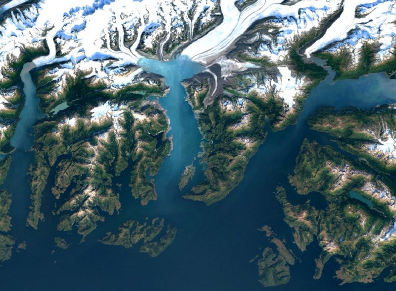
Remember when you last used Google’s satellite images? Most of us don’t. After the initial excitement of checking out satellite imagery through Google Earth or Google Maps, most of us switched to plain old maps thanks to our navigation needs (not to mention data consumption in case of cell phones). Google is ready to make you revisit its satellite images by introducing greater detail and sharpness in its images.

The lack of clarity and detail had made satellite images a dull affair. However, now Google will make use of images captured by satellite Landsat 8, launched in 2013 as part of a joint programme between Nasa and US Geological Service offering accessible open data, which captures images with greater detail, true colours, and more frequency.

The images have been mined using Google’s Earth Engine API and are promised to be significantly better than the ones previously available. The company mined nearly a petabyte (700 trillion individual pixels) of satellite imagery to produce the improved images, it said in its blog.

The new satellite captures twice as many images as last satellite and hence one of the biggest problems- images ruined by cloud coverage-will now be solved. Google claims that it has used new processing techniques to get what it calls “freshest global mosaic to date.”

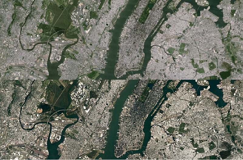
Below you can see the satellite imagery before the update, and after. With its own development in the satellite imagery field with the acquisition of Skybox Imaging – now Terra Bella – it’s evident Google doesn’t want to rely solely on third-party satellite data.
google_detroit_comparison.jpg

Download the Gadgets 360 app for Android and iOS to stay up to date with the latest tech news, product reviews, and exclusive deals on the popular mobiles.

Tags: Google, Google Earth, Google Maps, Mapping, Maps, Satellite Imagery
[“Source-Gadgets”]
TAGGED: Earth, get, Google, Imagery, Maps, Satellite, Sharper
sristy July 8, 2016
Previous Article Google to Now Show Song Lyrics in Search Results
Next Article Avatar Mobile Game to Launch Ahead of Film Sequels

Latest News

Due to the second wave of COVID-19
SMARTPHONE
Back to basics: How simple fitness outperforms every trend
FITNESS
Vivo T4 Pro Teased to Launch in India Soon; to Be Available on Flipkart
GADGETS
Explained: How the govt is planning to evaluate students’ fitness in schools
FITNESS
Doctors shouldn’t be allowed to object to medical care
HEALTH
How do I begin? Wellness and Fitness for Busy Women: A Guide
LIFESTYLE
Color options and design for the Samsung Galaxy S25 FE 5G mobile device have been teased ahead of launch
SMARTPHONE
The Truth about Protein
LIFESTYLE

Removed from reading list

Undo

Lost your password?